Home
Water Lane
Please note, we are also holding a consultation on a detailed design code for water lane, this can be viewed and responded to by going to https://waterlane.commonplace.is/
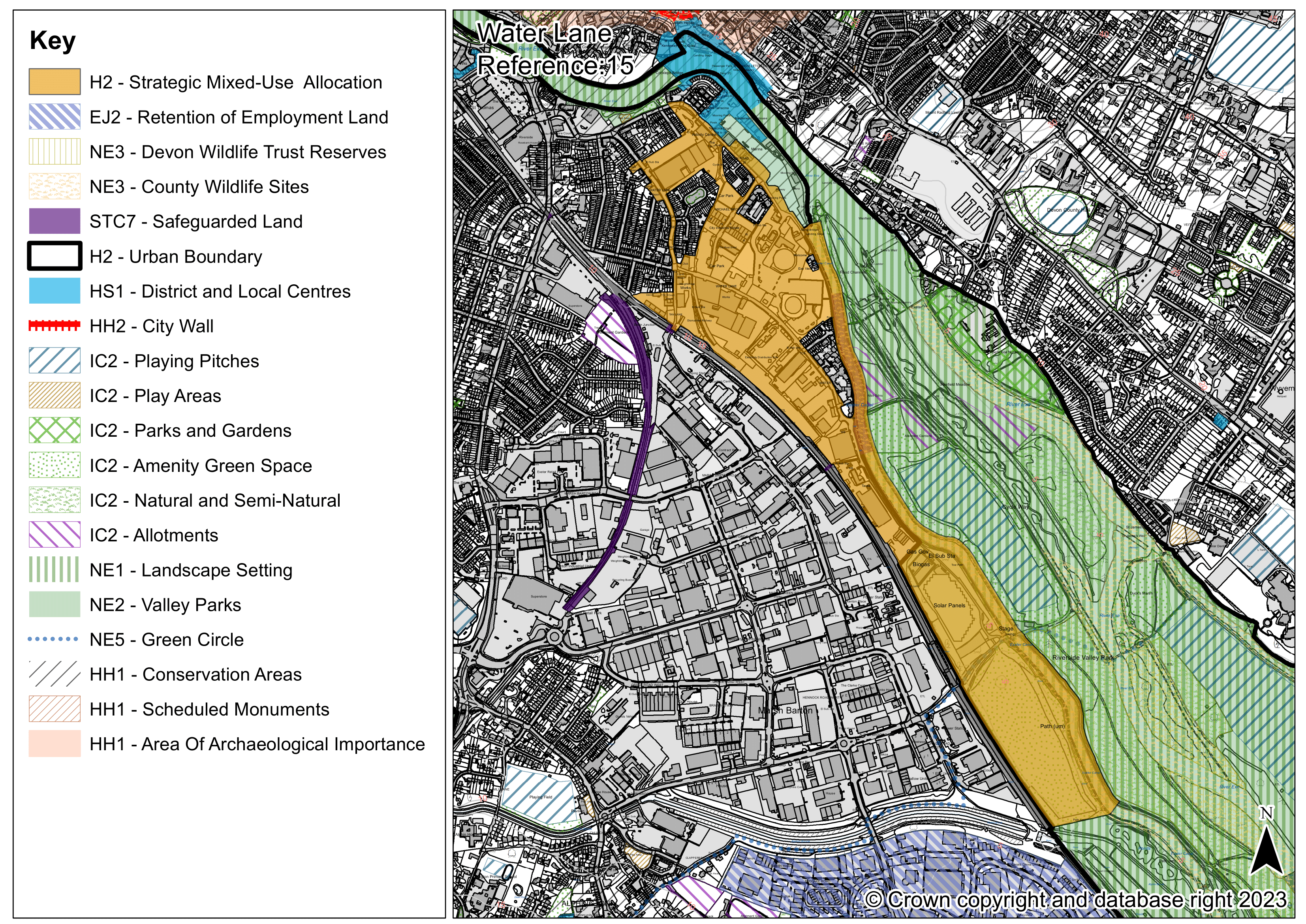
Water Lane: Site reference 15
Water Lane is one of the largest strategic sites proposed for allocation in the Exeter Plan, located between the Exeter Ship Canal and the Great Western Main Line railway. The site is brownfield and currently contains a variety of uses including business premises and workshops, utilities infrastructure, public car, coach and boat parking, leisure and community facilities including for water-based activities and Grace Road Playing Field (now disused). The site boundary has extended slightly since the last consultation to include the canal and the highway of Water Lane itself.
The majority of the proposed Water Lane allocation is already identified for mixed- use, residential-led redevelopment in the Exeter Local Plan First Review. The site is also included in the Liveable Exeter initiative. The City Council proposes to roll this allocation forwards into the Exeter Plan.
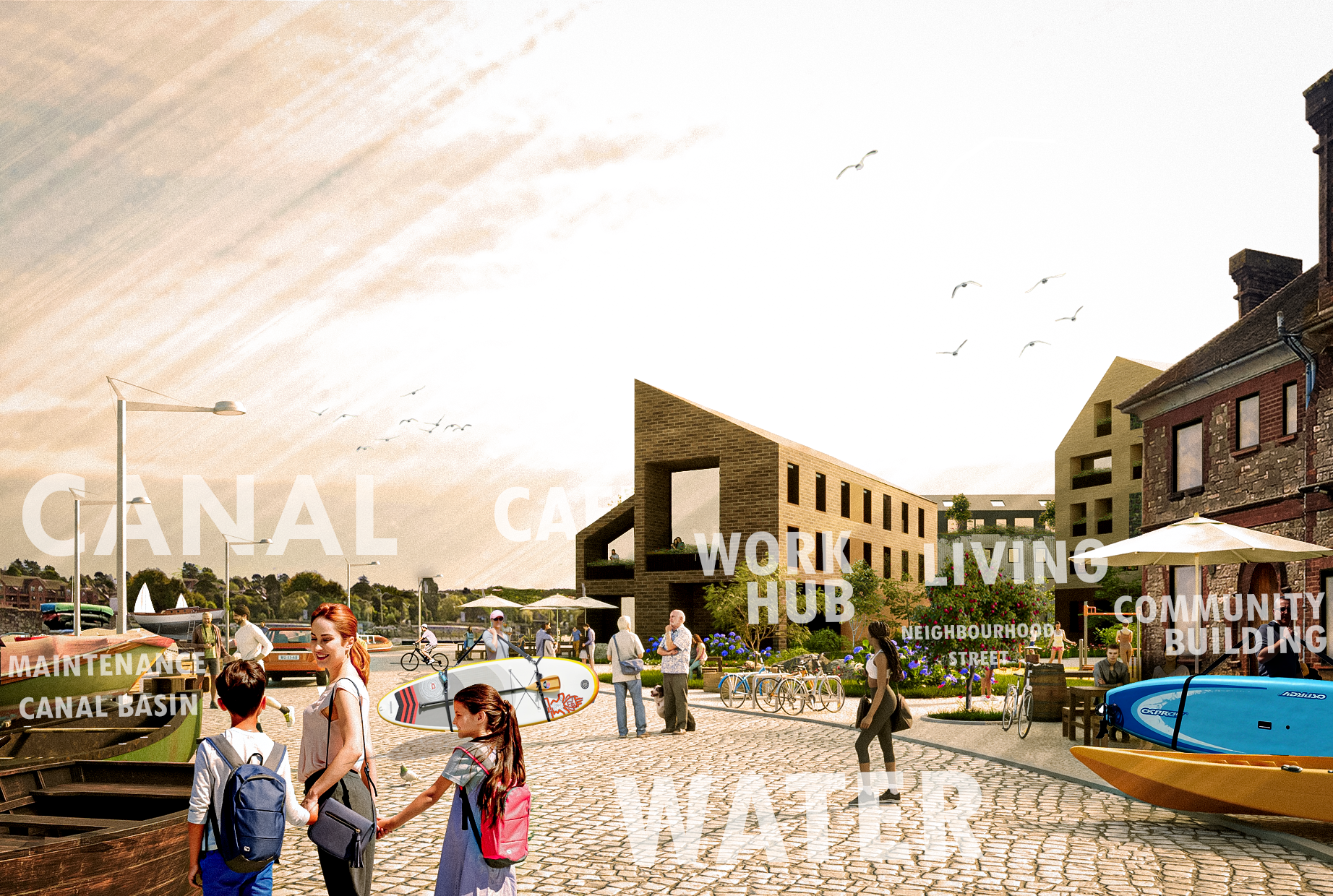
Water Lane provides a great opportunity to deliver a high quality, low-car new neighbourhood that is well served by a school, community, cultural and sustainable travel facilities (including the new Marsh Barton railway station), has good access to employment and links effectively to the Riverside Valley Park. Development will need to respond to challenges such as flood risk, restricted access, contamination, gas and electricity infrastructure and protecting the amenity of nearby residents. It will also need to reflect the site’s rich industrial and water-related heritage.
The proposed site allocation will be supported by a Liveable Water Lane Supplementary Planning Document (SPD), which is currently being prepared by the City Council and is also subject to consultation. The SPD will contain a development framework and design code for the site, alongside strategies for access and utilities provision, to help ensure that Water Lane is redeveloped in a comprehensive, co-ordinated way and at a high quality which reflects the Liveable Exeter principles.
Because this site is beginning to come forward for development now, early community engagement with local groups has been held to steer ideas for the Water Lane development recognising that this is a flagship regeneration area for the city.
The site is currently in multiple ownerships, including areas owned by the City Council while there are current planning applications for some parts of the site. The site boundary has changed slightly since the last Exeter Plan consultation to include the canal itself so it can be better enhanced by the proposals and include the road of Water Lane.
Consultation with the local community will be required before the submission of planning applications.
Water Lane – Reference 15 (Strategic policy)
A site of 36 hectares at Water Lane is identified for a mixed-use development delivering approximately 1,600 homes and the retention of existing levels of employment floor-space in phases up to 2040. The development must support the achievement of net zero and accord with the Liveable Exeter Principles and the Water Lane Design Code Supplementary Planning Document to deliver a compact and well-connected neighbourhood, incorporating the highest standards of design.
The following will be required:
A. A housing mix built to optimal densities taking account of local context and the Exeter Density Study which meets a wide range of housing needs including:
- 35% affordable homes for eligible households with a local connection or key workers, of which 50% will be for social rent, 13% for affordable rent, 25% for First Homes with a discount of 30% on market prices and the remainder for additional affordable homeownership;
- Custom and self-build plots;
- At least 10% of market homes and 10% of affordable homes built to meet wheelchair adaptable standards and all other homes built to meet accessible and adaptable standards;
- A range of dwelling sizes that takes account of local need; and
- A 70 unit extra care housing scheme.
C. A locally accessible neighbourhood centre including:
- Public realm that provides space for community and cultural activities;
- A community building with hall, meeting rooms and flexible space for potential library provision, youth, adult’s services, children’s services and cultural activities;
- New surgery providing GP, pharmacy and other community healthcare or contributions to GP provision;
- Retail or commercial units with active ground floors accommodating local shops and services;
- A work hub;
- A mobility hub;
- A 2-form entry primary school including early years and communal space for children's centre service provision and contributions to secondary and special educational needs provision; and
- Provision of additional space for water-related activities and safeguarding of the infrastructure needed to support strategic water-related uses.
D. Transport infrastructure to deliver a low-car development:
- A layout in accordance with active design principles, with Water Lane providing an active travel spine to the neighbourhood centre and Marsh Barton Station, improved active travel routes along the Canal frontage and frequent, active green streets running towards the River Exe;
- Low-car development supported by active travel measures that include mobility hubs to provide for public transport, active travel and shared mobility;
- Provision of infrastructure for and contributions to public transport;
- Delivery of or contributions to a new pedestrian and cycle crossing of the Canal and River Exe;
- Contributions to off-site active travel routes including priority schemes in the Exeter Local Cycling and Walking Infrastructure Plan;
- The provision of improved active travel and public transport access at Tan Lane under the Great West Mainline towards Marsh Barton; and
- Electric vehicle charging points throughout the site.
- Enhancement of the natural environment and Green Infrastructure:
E. Enhancement of the natural environment and Green Infrastructure:
- Green Infrastructure provision in accordance with the Green Infrastructure Strategy including contributions to off-site provision
- A mix of open space provision including for sport and recreation;
- High quality green infrastructure linking to the Exeter Ship Canal and Riverside Valley Park; and
- Mitigation contributions to ensure no adverse effect on the European Sites, in accordance with requirements set out in the South-east Devon Mitigation Strategy; and
- Biodiversity enhancements.
F. An energy strategy that minimises carbon emissions (both operational and embodied), incorporates renewable and low carbon energy generation and helps to deliver, and connect to, local energy networks.
G. Appropriate measures to respond to, and ensure the continued operation of, the gas and electricity infrastructure network across the site.
H. Appropriate flood risk mitigation:
- A layout informed by a detailed flood risk assessment which addresses flood risk from all sources ensuring consistency of approach with Marsh Barton;
- Sustainable Urban Drainage to mitigate against flood risk and provision of the necessary infrastructure to help deliver the Drainage and Wastewater Management Plan; and
- Delivery of, or contributions to, an emergency access and egress route and access bridge over the Great Western Mainline linking to Marsh Barton.
- A layout informed by archaeological and heritage assessment, evaluation and mitigation;
- A built form that enhances the character and appearance of the Riverside Conservation Area and protects the settings of all listed buildings; and
- Enhancement of the historic Canal, with key buildings, materials and industrial structures including the Gas Works Former Manager’s House retained and reused creatively to support a distinct character rooted in the area’s history.
Note: Policy not yet tested by viability appraisal.
You can use the slider on the image below to view an illustrative example of how the site might look in the future.

This engagement phase has finished

...